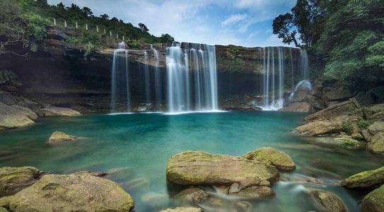
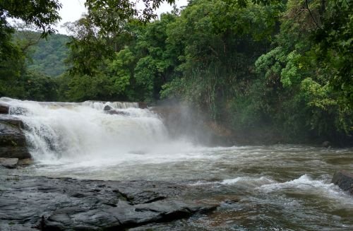
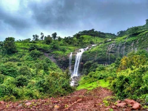
Zanzari Waterfall is not a tall mountain cascade. It is a rocky waterfall on the Vatrak River, where the river passes over naturally eroded rock and forms a series of small drops, pools and channels. The setting becomes especially attractive during the monsoon, when the surrounding countryside turns green and the river carries more water.
Although Zanzari is often described online as being in Sabarkantha or near Dehgam, its current administrative location is near Dabha village in Bayad taluka of Aravalli district, Gujarat. The official Aravalli district website places it about 12 km from Bayad and around 7 km south of the Bayad–Dahegam road. It is a popular day trip for people travelling from Ahmedabad, Gandhinagar and nearby parts of North Gujarat.

Zanzari Waterfall: Quick Facts
- Location: Near Dabha village, Bayad taluka, Aravalli district, Gujarat
- River: Vatrak River
- Distance from Bayad: about 12 km
- From Bayad–Dahegam Road: about 7 km south
- Nearest major city: Ahmedabad
- Nearest airport: Sardar Vallabhbhai Patel International Airport, Ahmedabad
- Nearest practical bus point: Bayad
- Access: road journey followed by a walk over open and rocky terrain
- Timings: no reliable official fixed opening hours are published; visit during daylight
- Entry fee: no standard official entry fee is currently published
- Best season: monsoon and early post-monsoon
- Ideal visit: early morning, especially on weekends
What Is Zanzari Waterfall Like?
Visitors expecting a very high waterfall may be surprised. Zanzari’s attraction comes from the Vatrak River flowing through a broad rocky landscape, rather than from one huge vertical drop.
The rock beneath the falls has been naturally eroded, creating depressions and water-filled cavities. The Aravalli district administration specifically notes the hard-rock formations and water-filled chasms around the waterfall.
This landscape makes Zanzari particularly photogenic when the river is flowing well. It is also why visitors need to be cautious: apparently calm sections can hide deeper holes, uneven rock and stronger currents.
Another local attraction is the Ganga Mata temple in the area, where the official district tourism page describes a spring associated with continuous abhishek of Shiva.
Zanzari Waterfall Timings and Entry Fee
There are conflicting timings online. Some commercial listings describe Zanzari as open 24 hours, while older visitor reports recommend roughly 7 AM to 6 PM. The official Aravalli district tourism page does not currently publish fixed opening and closing hours.
For practical purposes, treat Zanzari as a daylight destination. An early-morning visit is preferable because:
- The temperature is usually more comfortable.
- You have enough daylight for the walk.
- Weekend crowds generally increase later in the morning.
- The rocky terrain is easier to navigate in good light.
There is also no clearly published official admission fee. Parking or local services may involve separate charges, so carrying some cash is useful.
The Walk to Zanzari Waterfall
Don’t expect to park your vehicle directly beside the main cascade.
Visitor reports describe a walk of roughly 1.5–3 km, depending on where vehicles can be parked and the route being used. Conditions can change after rain. Parts of the route are open, rocky and muddy rather than a developed paved tourist trail.
Wear proper walking shoes and carry:
- Enough drinking water
- A hat or other sun protection
- Light snacks
- Shoes with good grip
- Minimal luggage
- Rain protection during the monsoon
The walk can be tiring for small children, older visitors and anyone with mobility problems, particularly in hot or wet weather.
Best Time to Visit Zanzari Waterfall
Zanzari is strongly influenced by seasonal rainfall. July to September is generally the most rewarding period for scenery and water flow, although the exact experience depends on that year’s rains.
The monsoon brings green surroundings and a stronger waterfall, but it also creates the highest safety risk. Rocks become slippery, muddy stretches develop on the approach, and river currents can become considerably stronger.
The late monsoon and early post-monsoon period can therefore offer a better balance between good water flow and easier conditions.
Summer is less attractive for a waterfall-focused trip. Recent local visitor discussions also report low water and uncomfortable heat before the monsoon arrives.
How to Reach Zanzari Waterfall
From Ahmedabad
Zanzari is a popular road trip from Ahmedabad. Drive towards Dahegam and Bayad, then take the local route towards Dabha and Zanzari. Because the final approach uses rural roads, navigation can become less straightforward than the main highway journey.
A private car or motorcycle is generally the most convenient option.
From Gandhinagar
Travellers from Gandhinagar can head towards Dahegam and continue in the direction of Bayad before turning towards the Dabha/Zanzari area.
From Bayad
Bayad is the closest useful town. According to the Aravalli district administration, the waterfall is approximately 12 km from Bayad, with the site about 7 km south of the Bayad–Dahegam road.
By Bus
Regular buses connect Bayad with other cities and towns. From Bayad, however, you will need local road transport towards the waterfall area.
By Train
Rail is less convenient than road for reaching Zanzari directly. The official district page notes local train services on the Modasa–Nadiad side, but visitors will still need road transport for the final journey.
By Air
The official Aravalli tourism page identifies Ahmedabad as the nearest airport, at approximately 100 km from the waterfall. From the airport, continue by road towards Dahegam, Bayad and Dabha.
Nearby Places to Visit
Zanzari works well as a dedicated half-day trip, but travellers exploring this part of Gujarat can also consider:
- Bayad: the nearest main town and the most useful stop for fuel, food and other supplies.
- Ganga Mata Temple: located in the Zanzari area and associated with the natural spring mentioned by the district tourism authority.
- Shamlaji Temple: an important pilgrimage destination on the Meshwo River in Aravalli district.
- Devni Mori: an archaeological site near Shamlaji associated with an ancient Buddhist monastery and stupa.
- Utkantheshwar Mahadev area: another religious destination associated with the river landscape of the wider region.
Shamlaji and Devni Mori are better suited to a longer Aravalli district itinerary than a quick detour from the waterfall.
Safety at Zanzari Waterfall
The biggest mistake at Zanzari is assuming that a relatively small waterfall means harmless water.
The rocky riverbed contains deep depressions and water-filled chasms, and recent local discussions repeatedly warn visitors about hidden depths, currents and slippery rocks.
For a safer visit:
- Do not jump or dive into unknown pools.
- Keep away from strong currents after heavy rainfall.
- Don’t stand close to slippery edges for photographs.
- Keep children under close supervision.
- Avoid visiting during severe rain or flooding.
- Return before dark.
- Carry your rubbish back rather than leaving bottles or food packaging near the river.
Zanzari Waterfall FAQs
Q1. Where exactly is Zanzari Waterfall?
A: Zanzari Waterfall is on the Vatrak River near Dabha village in Bayad taluka of Aravalli district, Gujarat. Older descriptions may still associate the area with Sabarkantha.
Q2. What are the timings of Zanzari Waterfall?
A: The official district tourism page does not publish fixed opening hours. Although some online listings describe it as accessible around the clock, visiting during daylight, preferably in the morning, is the safer practical choice.
Q3. Which month is best for Zanzari Waterfall?
A: July to September is generally best for stronger water flow and greener scenery. Avoid entering the river when monsoon currents are strong.
Q4. How far is Zanzari Waterfall from Bayad?
A: The Aravalli district administration places the waterfall approximately 12 km from Bayad and about 7 km south of the Bayad–Dahegam road.
Q5. Is swimming safe at Zanzari Waterfall?
A: It is better not to treat Zanzari as a swimming spot. The rocky riverbed can contain deep cavities, while currents and slippery surfaces become particularly dangerous when water levels rise.